Types of Disasters

Flood

Fitzroy River Flood Maps

Flood

Flood season in Australia and across Livingstone Shire is between November and April.

Livingstone Shire Council regulates development in areas with potential to be impacted by natural hazards via the Livingstone Planning Scheme 2018 . Natural Hazards includes Flood Hazard Areas. The Planning Scheme determines if development requires approvals – this includes minimum habitable floor levels and other requirements. The maps provided through the Disaster Dashboard are not to be used for development application purposes. The maps below give an indication of the observed river height and subsequent flood hazard extent when the Yaamba gauge is at 16m and the Rockhampton gauge is at 9.5m.

View Livingstone Shire Flood Maps

There are three common types of floods that affect Australia.

  • Slow On-set Floods
  • Rapid On-set Floods
  • Flash Flooding

Slow On-set Floods

Inland rivers in the vast, flat areas of Queensland often flood. These floods may take days to build-up, but can last for weeks or even months.

The damage caused by slow on-set floods includes:

  • major loss of livestock
  • rural towns being cut-off and isolated
  • crop damage
  • damage to roads and railways

Rapid On-set Floods

Rapid on-set flooding occurs more quickly than slow on-set flooding. Rapid on-set floods can be much more damaging and pose a greater risk to loss of life and property because there is generally less time to take preventative action from a faster, more dangerous flow of water. This type of flooding can affect most of our major towns and cities.

Flash Flooding

Flash flooding, which is the most common in the Livingstone Shire, results from relatively short, intense bursts of rainfall, often during thunderstorms. It can occur in almost all parts of Australia and poses the greatest threat to life. People are often swept away after entering floodwaters on foot or in vehicles. These floods can result in significant property damage and major social disruption. They are a serious problem in urban areas where drainage systems are often unable to cope with large amounts of water in a short time.

Be Prepared!

  • Tune into your local radio station and listen out for warnings and alerts
  • Stack your furniture and possessions above the likely flood level. Make sure you have your electrical equipment on top
  • Secure objects that could float and cause damage
  • Prepare your vehicle by ensuring you have enough fuel if you were required to evacuate and move it to high ground
  • Check your Emergency Kit is stocked with essential items to assist if you were to be isolated or without power.
  • Ensure your pantry is full of non perishable food items
  • Don't forget your pets and/or animals. Make sure your pets are safe out of flood water and if you live on a farm move cattle to higher ground

Visit the Disaster Dashboard for up to date information.

Bushfire

Bushfires in Livingstone

Bushfires can occur at any time of the year in the Livingstone Local Government Area (LGA). However, peak bushfire activity typically occurs after the dry winter months and during spring. Bushfires can cause significant damage to property, loss of human life and animals, destruction of forests, environmental impacts, and substantial economic costs.

Livingstone's Disaster Dashboard includes a dedicated Bushfire tab on the top left-hand side of the page. This is a valuable source of information, including the current Fire Danger Rating (FDR). Fire Danger Ratings indicate how dangerous a fire could be if one started in your area today. They provide important information to help you take action to protect yourself, your family, and your property.

During periods of elevated bushfire risk, check the Fire Danger Rating for your area daily.

Fire 1.png

The Australian Warning System provides a nationally consistent approach to emergency information and warnings for hazards such as bushfires, floods, storms, extreme heat, and severe weather.

Fire 2.png

The symbols shown above represent bushfire warning levels, with each level accompanied by specific action statements to help the community respond appropriately:

  • Yellow – Advice
  • Orange – Watch and Act
  • Red – Emergency Warning

Prepare for Bushfires

Fire embers can travel several kilometres ahead of a bushfire, placing your property at risk long before the flames arrive.

Visit the Queensland Fire Department (QFD) website for information on how to prepare your home and property for bushfire.

On private property in Livingstone Shire, outdoor fires are only permitted in a fireplace constructed to prevent fire or burning material from escaping or where authorised by the Queensland Fire Department.

If you are planning to burn, visit the Find Your Fire Warden website for important information, including how to locate your local fire warden and apply for a Permit to Light.

Landowners may apply to burn local road reserves and other Council-controlled reserves adjacent to their properties. If you wish to burn along a state-controlled road, contact the Department of Transport and Main Roads. To apply to conduct controlled burning within a Council-controlled Road reserve, complete and submit an Application to Conduct Controlled Burning within a Council-Controlled Road Reserve.

For further information, lodge a customer request through the Online Service Centre or contact Customer Support on (07) 4913 5000.

Know Your Risk

Do you live in a bushfire-prone area?

Use the Post Code Checker map to identify bushfire risk in your area.

You can also access the Disaster Prepared Communities Portal to complete a preparedness check and map your location. Use the Layer Control function to determine whether your property is within a bushfire-prone area.

Have a Plan

Create a Bushfire Survival Plan and prepare your property and household now, so everyone knows what to do if a bushfire threatens your home.

Monitor Conditions

Visit the Livingstone Disaster Dashboard to access:

Cyclone

Cyclone

Cyclone Season in Australia is between November and April.

Cyclones are violent storms that contain high winds rotating around a calm centre of low pressure. Winds produced can be in excess of 200km/hr which can cause extensive damage, and can result in death or injury caused by flooding, buildings collapsing or flung debris.

The Bureau of Meteorology (BOM) is Australia's national weather, climate and water agency. Its expertise and services assist Australians in dealing with the harsh realities of their natural environment including drought, floods, fires, storms, tsunami and tropical cyclones. For more information visit the BOM website.

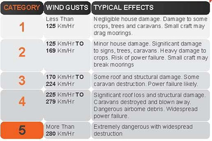
Cyclone Categories

Cyclones are categorised into 5 categories and when a cyclone warning is issued, these categories will help you determine what level of precautions you will need to take, and what damage can result.
Cyclone Categories

It is important to have a thorough understanding of cyclones and the impact that they can have on our Shire. Ensure you take the time to visit the Get Ready website and take the necessary precautions.

Cyclone Warnings

A tropical Cyclone Warning includes information on where the cyclone is, what its movement and direction is, and how strong it is and, identifies the areas that could be affected or at risk.

Tropical cyclone watch: Issued if a cyclone is expected to affect coastal communities within 48 hours, but not expected within 24 hours.

Tropical cyclone warning: Issued if a cyclone is affecting or is expected to affect coastal communities within 24 hours.

Information on current cyclone warnings can be found on the BOM website

Visit the Tropical Cyclone Knowledge Centre to gain a better understanding

Be Prepared!

To be prepared in the event of a cyclone, check your house and roof is in good condition; trim tree branches well clear of your house; clear property of loose sheet iron and other potential missiles (including outdoor furniture); prepare an emergency kit including a battery-operated radio; upon a Cyclone Warning, listen to radio (837AM ABC) and/or television for further advice.

Make sure you fill as many water containers as possible, close shutters, board up or heavily tape all windows, prepare the strongest part of your building (usually an internal hallway or bathroom) using strong tables and mattresses and beware of the eye of the storm.

Secure boats and caravans, move vehicles and bicycles undercover. Charge electronic devices. Decide how you will look after your pets and animals, and what you will do if you have to leave them behind. Pets are not permitted in cyclone or evacuation centres. Let your neighbours know a cyclone watch/warning has been issued.

As a property owner you will need to identify whether you will evacuate your property or wait the cyclone out within your home.

Properties constructed after 1982 are generally structurally sounds to withstand a cyclone.

Visit the Disaster Dashboard for up to date information

Storm Tide

Storm tide

A storm surge is water produced by a cyclone, and can be many kilometres wide and several metres higher than a normal tide. Storm surges may have abnormally high tides, destructive wave action and can result in increased flooding. Therefore, a storm tide = Normal tide + Storm Surge + Wave Setup.

All cyclones produce storm surges but not all surges are not dangerous. The level of danger will depend on the strength of the cyclone, its speed, the shape of the sea floor, the features of the land, the angle it crosses, the coast and most importantly WHEN it makes landfall.

Storm Tide Hazard Interactive Mapping

Be Prepared!

Always be prepared for the likelihood of a storm surge during cyclone season. If you live in a low-lying coastal area look at the storm surge map that shows the possible impact it can have on your area, ensure your property is adequately prepared by taking the necessary precautions for a cyclone, and those necessary for normal flooding.

The storm surge maps available indicate the approximate storm surge inundation limits. These limits depend on the severity of the cyclone and other external factors.

Visit the Disater Dashboard for up to date information

Heat Wave

Heatwave

Heatwave season in Australia is between November and February.

A heatwave is 3 or more days where the maximum and minimum tempertures are unusually high for a location.

Heatwaves are classified into 3 types:

  • Low intensity heatwaves - more frequent during summer and most people can cope
  • Severe heatwaves - less frequent and can be more challenging for the elderly and those with medical conditions
  • Extreme heatwaves - rare and are a problem for people who don't take pre-cautions to keep cool. People who work or exercise outdoors are at greater risk of being affected

During heatwaves, there is an increase in emergency calls from people suffering heat-related illness. While the very young and the elderly are most at risk, anyone can be affected.

How to avoid heat-related illness

  • drink water regularly
  • keep out of the heat as much as possible
  • block out the sun during the day
  • take frequent cool showers or baths and splash yourself several times a day with cold water, particularly your face and the back of your neck
  • use fans or air-conditioners at home to keep cool or spend time in an air-conditioned library, community centre or shopping centre
  • if you go out wear lightweight, breathable clothes and rest in the shade

Don't forget your animals, they can also be affected by heat-related illness. Ensure they have appropriate shade and water.

Visit the Heatwave Knowledge Centre to gain a better understanding.

Heat-related illness occurs when the body absorbs too much heat. This may happen slowly over a day or two of very hot weather. Act quickly to avoid serious - or even fatal - effects of fully developed heat stroke. Early signs of heat stress:

  • rising body temperature
  • dry mouth and eyes
  • headache
  • shortness of breath
  • vomiting
  • absence of tears when crying.

Be Prepared!

  • If you have a medical condition, ask your doctor for advice on how to manage the heat.
  • Plan ahead to reduce the risk of getting heat exhaustion or a heat-related illness
  • Think of simple ways to make your home or building cooler (e.g. install awnings, shade cloth or internal blinds or curtains on the sides of the building that face the sun)

Have any air conditioners serviced before the beginning of summer.

Visit the Disaster Dashboard for up to date information

Tsunami

Tsunami

A tsunami is a series of powerful, fast moving waves produced during a large scale ocean disturbance. Tsunamis can occur with very little warning and are caused by a variety of events such as earthquakes, volcanic eruptions, explosions or landslides.

A tsunami is different from a wind generated surface wave on the ocean. The passage of a tsunami involves the movement of water from the surface to the seafloor which means its speed is controlled by water depth. Consequently, as the wave approaches land and reaches increasingly shallow water it slows. However, the water column still in deeper water is moving slightly faster and catches up, resulting in the wave bunching up and becoming much higher. A tsunami is often a series of waves and the first may not necessarily be the largest.

When a tsunami travels over a long and gradual slope, it allows time for the tsunami to grow in wave height. This is called shoaling and typically occurs in shallow water less than 100m. Successive peaks can be anywhere from five to 90 minutes apart. In the open ocean, even the largest tsunami are relatively small with wave heights of less than one metre. The shoaling effect can increase this wave height to a degree such that the tsunami could potentially reach an onshore height of up to 30 metres above sea level. However, depending on the nature of the tsunami and the nearshore surroundings, the tsunami may create only barely noticeable ripples.

Tsunami Interactive Map

The Joint Australian Tsunami Warning Centre (JATWC)

Geoscience Australia receives real-time data from over 50 seismic stations in Australia, and more than 120 international seismic stations. The seismic data are analysed by specifically designed automated systems to alert for potentially dangerous earthquakes. Expert seismologists then use the results of the automated process to quickly make a final analysis of the potential for the detected earthquakes to cause a tsunami. The analysis is immediately transmitted to the Bureau of Meteorology.

Equipped with the seismic information from Geoscience Australia and the Bureau's scientific tsunami modelling, specially trained staff at the Bureau then issue a warning that is in keeping with the threat level. JATWC continuously monitors all the relevant real-time sea-level observations to verify whether a tsunami has been generated and whether it is moving along the predicted path, and to provide timely updates of warnings. The JATWC is leading the world by providing warnings for Australia that identify not only affected coastal regions, but also whether the tsunami has the potential to cause inundation to low-lying coastal areas with need for major evacuation (land threat), or whether it is confined to dangerous rips and currents and some localized overflow onto the immediate foreshore with no need for major evacuation (marine threat).

The Bureau issues advice and warnings on any identified tsunami threat to emergency agencies, relevant authorities, media and the general community using the the same systems and infrastructure as used for warnings of other hazardous events such as severe weather.

Be Prepared!

Although the Livingstone Shire doesn't have any active volcanoes and hasn't had any large earthquakes it's important to remember that a tsunami can be formed by landslides on the sea floor and land slumping into the ocean.

If a tsunami threat has been identified via the JATWC the Standard Emergency Warning Signal (SEWS) will be sounded to notify the public.

The warning signs

  • As a tsunami approaches the shoreline, water may recede from the coast exposing the ocean floor, reef and fish.
  • An approaching tsunami creates a loud "roaring" sound similar to that of a train or airplane.

If you notice any of those signs head for higher ground.

Visit the Disaster Dashboard for up to date information